5 myths about mercury in Madre de Dios

A new study found unsafe amounts of mercury in fish and people in Puerto Maldonado, the capital of Peru’s southeastern Madre de Dios Region. Average mercury levels in nine of the 15 most commonly consumed fish species were above the limit recommended by the U.S. Environmental Protection Agency. Farmed fish had the lowest levels, according to Luis Fernández of the Carnegie Institution for Science’s Global Ecology Program at Stanford University in the United States, who led the study.

Seventy-eight percent of adults tested in Puerto Maldonado had levels that were more than twice the recommended limit for humans. The highest levels – three times the recommended threshold – were found in women of childbearing age. That is especially alarming, because mercury can damage the developing fetus’ neurological system.
Continue reading

Telltale hairs reveal mercury in Peruvian miners’ bodies

A new study shows that mercury from wildcat gold mining in the Peruvian Amazon is accumulating in the bodies of miners and other people in Peru’s southeastern Madre de Dios region. The analysis of mercury in hair samples reinforces a study by Peruvian health officials in 2010, which found high levels of mercury in some miners’ urine.

In the new study, published last week in the on-line journal PlosOne, Katy Ashe of Stanford University analyzed hair samples from 100 people (38 men and 62 women) in three mining camps and 104 people (60 men and 44 women) inPuerto Maldonado, the capital of Madre de Dios. The highest levels were found in men in the mining camps and in people who reported eating fish more than 12 times a month.

Mercury accumulates in the tissues of organisms. Large fish eat mercury-contaminated smaller fish, and they, in turn, become meals for humans. The effect biomagnifies it goes up the food chain. Mercury is linked to neurological and developmental problems in humans and is especially dangerous to developing fetuses.

Ashe’s study sample was small and not scientifically designed, largely to protect study participants and the researchers from possible aggression by people in the mining camps. She concludes that further study is warranted. And her work highlights a critical point that has gotten lost amid protests by miners fighting recent legislation aimed at curbing wildcat gold mining: mercury in the environment is a long-neglected public health problem in Peru.

Ashe K (2012) Elevated Mercury Concentrations in Humans of Madre de Dios, Peru. PLoS ONE 7(3): e33305. doi:10.1371/journal.pone.0033305

Can’t see the forest for the (palm) trees

Oil palm plantations in Kalimantan – the Indonesian name for the island known in English as Borneo – are expanding at the expense of forest, leading to an increase in carbon emissions, according to a study published October 7 in Nature Climate Change . The study found that 90 percent of the land converted to oil palm between 1990 and 2010 was forested. Nearly half of that area was intact forest, while the rest had been logged or was being used for agroforestry.

The study was led by Kimberly Carlson, a doctoral candidate at Stanford University, using a system designed by Gregory Asner of the Carnegie Institution for Science at Stanford. Asner has been using that system to map carbon stocks in the Peruvian Amazon, as well as in Colombia and Ecuador.

Borneo’s rain forest, which is known for its biological diversity, has long been under siege, first from heavy logging and now from oil palm plantations. The new study found that carbon emissions from land conversion for oil palm plantations totaled 0.09 gigatons between 1990 and 2000 and 0.32 gigatons between 2000 and 2010, and is likely to increase to 1.21 gigatons between 2010 and 2020 if all of the leases that have been granted are developed.

Although the situation in Peru is not quite the same, partly because conversion of peatland to plantations adds a significant amount to Kalimantan’s carbon emissions in Indonesia, palm oil plantations are also cutting into old-growth forest in the Peruvian Amazon, according to a study published late last year.

From the air, the neat, new rows oil palm in the departments of San Martín andUcayali look like cross stitching. Many of the trees are being planted by small farmers hoping for something more lucrative than traditional crops. Because they have little land and little capital, their yield is lower than that of the large industrial plantations, according to the study, but they are more likely to plant on degraded land, instead of cutting down old-growth forest for oil palm. Industrial plantations are more mechanized and have higher per-hectare yield, but 72 percent of their expansion between 2000 and 2010 came at the expense of old-growth forests, according to the study, which was led by Víctor Gutiérrez-Vélez of Columbia University and published in Environmental Research Letters.

Tax breaks and a law requiring a minimum amount of biodiesel in vehicle fuel have helped spur the expansion of oil palm cultivation in Peru in the past decade. Peru has more than 50,000 hectares of oil palm now, and industry and government officials have said it could expand to 1.4 million hectares.

But the Ministry of the Environment has also set a target of zero net deforestation by 2021. Former Environment Minister Antonio Brack was adamant that plantations should not replace standing old-growth forest, but should be developed on some of the millions of hectares of degraded land in the Peruvian Amazon. The problem with that, say Gutiérrez-Vélez et al., is that those lands often have titling problems, making them less attractive to large-scale producers. So while large-scale plantations are more efficiently – meaning they could produce more using less land – they are more likely to destroy mature forest.

Fragmented forests change the hydrological cycle, are more susceptible to fire and often have less biodiversity than larger intact forests. The studies from Peru and Indonesia indicate that if palm oil plantations are to coexist with old-growth forest in Peru, there must be incentives to use degraded land, rather than destroy forest for plantations; steps must be taken to mitigate indirect impacts, such as those from roads built to the plantations; and monitoring is crucial, to be sure that oil palm does not become a net source of carbon as well as deforestation.

Dammed if they do …

It’s been one dam story after another in South America in the past week or so.

The 2,750 Mw HidroAysén dam in southern Chile got the green light from an appeals court after a three-month suspension to review objections from environmentalists.

The on-again-off-again Belo Monte dam in Brazil is off again, at least for the moment. A judge suspended construction because of the likely impact on fish stocks and local communities that depend on fisheries. The dam would also flood an area occupied by indigenous people.

But flooding – with the related methane emissions, as Philip Fearnside of Brazil’s Amazonian Research Institute has pointed out – is not the only environmental impact of a dam like Belo Monte. As with most megaprojects, people flock to the area looking for work … and tend to stay, clearing land and putting even more pressure on natural resources.

The Belo Monte project is not one dam, but a series of dams planned for the Xingú River. Upstream dams can be used to control the flow of water to hydroelectric plants further downstream. That is why plans for the Inambari damin southeastern Peru are probably not dead yet, even though government officials insist that it is not on the table. Besides generating some 2,000 Mw of electricity – mainly for export to Brazil, because Peru doesn’t need that amount of additional energy right now – the Inambari dam would be used to control the flow of water downstream to a series of dams on the Madeira River in Brazil.

Planners tend to look at hydroelectric dams in terms of kilowatt hours and flow control. But a river is more than a conduit for water – it’s an entire complex ecosystem, as Ernesto Raez of the Center for Environmental Sustainability atCayetano Heredia University in Lima points out. This animated video from the center is an excellent introduction to Amazonian river ecosystems and the impact of dams.

Inambari is only one of a number of hydroelectric projects on the drawing board for the Peruvian Amazon, and Brazil is the country most interested in seeing them built. Many would flood indigenous communities – which means they will face local consultation processes under the new “prior consultation law” signed by Peruvian President Ollanta Humala in September 2011. Most would be located on the steep eastern slope of the Andes mountains – a steeply inclined area with a lot of rivers, but also one of the most unexplored regions on the continent.

Because it’s the place where the Andean and Amazonian ecosystems meet, thecloud forest is one of the hottest of the world’s biodiversity hot spots. Ecuador’sYasuní Biosphere Reserve is usually cited as one of the most biodiverse places on the planet, but tropical ecologist Greg Asner of the Carnegie Institution for Science at Stanford University says that is probably because most of the rest of the cloud forest in Ecuador and Peru hasn’t been explored, as the area is very remote and access is difficult.

So there’s no real base line against which to compare the impact of a dam , a highway or any other “development” project that will bring people into an unstudied ecosystem. No one can say for certain what will be lost, because no one really knows what’s there. And a two-week – or two-month – environmental impact study would not even scratch the surface.

It is ironic that the resurgence of interest in major hydroelectric projects in South America comes just as the United States is ditching dams and restoring rivers to their natural state. A World Bank energy expert told me a couple of years ago that the new hydroelectric projects in Latin America would be kinder, gentler dams, but the Belo Monte, Madeira and Inambari projects look like the big dams of the past. There’s no question that Latin American countries will have to meet increasing demand for energy as their economies continue to grow, but instead of rushing to clog the western Amazon basin with dams, each country should perform a realistic projection of future needs and an honest assessment of its options – and their economic, environmental and social impact – with full transparency and public participation.

Alluvial gold mining

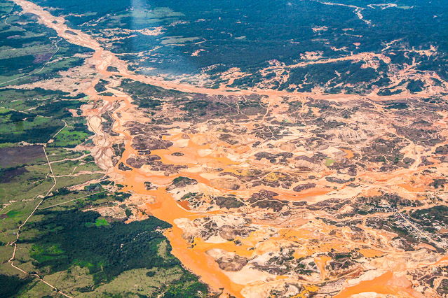
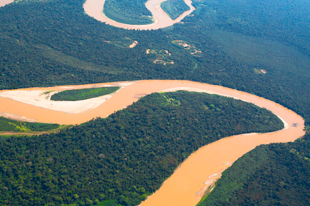
The Andes Mountains are rich in minerals, including gold. Over millions of years, erosion has carried gold down the eastern slope of the Andes and deposited it along river beds, leaving larger nuggets upstream and finer grains downstream. The tropical rivers have meandered constantly since the Andes began forming about 40 million years ago, spreading the golden wealth over the Amazonian plain in old streambeds long since overtaken by forest. Pre-Columbian settlers discovered the bounty. Gold artifacts date back at least to the Chimu culture (600 BC), and Spanish chronicles describe gold ornaments found in — and plundered from — the Inca capital of Cusco. Some of the gold used to make those objects might well have come from the alluvial deposits of eroded gold, or placers, in the rivers of Madre de Dios.

The earliest Peruvian miners probably stumbled on nuggets on sand bars and developed rudimentary sluices for separating them from silt, panning for gold like the California 49ers did. This kind of mining is known as artisanal mining. Today, however, miners often use gasoline-powered motors to power hoses that suck mud from the river bottom or from a pit in the forest, sending a cascade of cobbles and water over a carpet-lined wooden sluice. The miners work in teams. One runs the motor, another aims a high-pressure stream of water at a wall of mud, a third clears clogs from the suction hose, and the fourth monitors the sluice. After hours of hot, dirty, dangerous work, the miners collect the fine, dark sand that has settled on the sluice carpet, dump it into a barrel and add mercury from a small plastic flask, mixing it with their hands or treading it with their feet until the gold particles separate from the sand are cling to the mercury droplets, forming a “sponge.” They heat the sponge to vaporize the mercury, leaving behind a lump of gold.

This kind of mining causes deforestation, sedimentation of rivers and destruction of palm swamps. It also pollutes water, soil and air with mercury, which can cause neurological, gastric and other health problems. The greatest hazard to the miners comes from inhaling mercury when they head the gold sponge. Mercury in sediment and soil can undergo methylation, converting to a form that accumulates in animal tissue. Mercury levels concentrate more in animals higher up the food chain, so humans, otters or birds that eat fish that have eaten other fish are at greatest risk. This kind of gold mining is practiced by some 15 million people — including an estimated 4 million women and 1 million children — in more than 50 countries. They mine between one-quarter and one-third of the gold produced worldwide,and account for about 10 percent of the world’s atmospheric mercury emissions. In Peru, these small-scale miners produce nearly 10 percent of the country’s gold, most of it in Madre de Dios.

Efforts to control the impacts of artisanal mining involve bringing miners into the formal economy; improve health, safety and working conditions’ and reduce mercury use. In return, miners may be able to receive slightly for their efforts by selling their output as fair trade gold.

Andes mountains

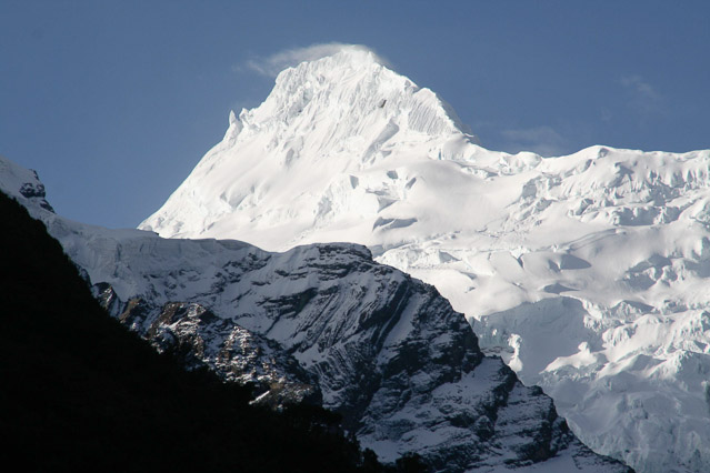
The uplift of the Andes mountains over millions of years has been due to a combination of plate tectonics and volcanism. Tectonic plates are sections of the earth’s crust that are in motion. Where they collide, they cause earthquakes and volcanoes and form mountains.

The South American plate, which carries the South American continent, is moving westward, colliding with the eastward drifting Nazca plate The collision has caused the heaving and folding known as orogeny, or mountain building, that has formed the Andes. As the leading edge of the Nazca plate sinks into the subduction zone under the South American plate, rock and sediment become molten and rise through cracks to emerge from volcanoes as lava. There are still active volcanoes all along the Andes, from Colombia to Chile.

Biogeographers divide the Andes into three segments – the northern, central and southern Andes, each with its own characteristics. Peru is part of thecentral Andes, which include some particular geological features, such as the split into the Cordillera Blanca and the Cordillera Negra in the Ancashdepartment in central Peru, and the Altiplano, a 3,800-meter-high plain in southern Peru, which includes Lake Titicaca. The highest peak in Peru is Mt. Huascarán, at 6,768 meters (22,200 feet). Peru also has the largest expanse of tropical glaciers in the world.

17-horses-30

Deforestation

More people moving to Amazonia usually mean more deforestation. Regionwide, most deforestation is due to clearing for agriculture, but in some areas of Madre de Dios, deforestation for alluvial gold mining has surpassed agriculture as the primary cause. Logging – legal and illegal – is also common in the region. In Brazil, clearcutting precedes agriculture. In Peru, logging is more selective, with loggers targeting particular valuable trees. Nevertheless, studies show that selective logging is more destructive than it appears. Studies show that for every tree felled for timber, at least 10 more fall around it or are cut to build logging roads. Selective logging also changes the species composition of the forest and can affect biodiversity in the long run. Continue reading

Sunset

Pacific coast

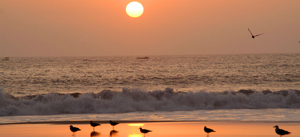
Peru’s coast is a long strip of desert cut in more than 50 places by seasonal rivers that flow from the Andes to the Pacific Ocean. But the coast has not always been arid. After South America broke away from Africa and the rest of Gondwana, the west coast was marshy. The uplift of the Andes Mountains, however, cut off the flow of moist air from the east, creating a rain shadow – an area where rainfall is scant to non-existent – and turning the coast into an arid strip of land with ocean on one side and mountains on the other. Chile’sAtacama Desert is one of the driest places on earth. The Peruvian desert, which is the northern extension of the Atacama, receives only about half an inch of precipitation annually. But while little moisture crosses the Amazon, the western Andean foothills do receive some moisture in the form of fog known as garua, creating an unusual ecosystem known as lomas.

Despite the harsh, dry conditions, many civilizations have flourished on the Peruvian coast. Many historians believe their rise and fall has been influenced by extreme weather, including weather influenced by the El Niño current, which periodically brings heavy rains to the usually arid coast. The river valleys provided arable land for crops, and both water and waterfowl were available in wetlands near the mouths of many of the rivers. Most of those wetlands have disappeared because of urban development, but some, like the Pantanos de Villa south of Lima, are protected areas.

The unusual equatorial dry forest ecosystem on the northern coast, in parts of the departments of Tumbes, Piura and Lambayeque, is home to endemic species of birds and vegetation especially adapted to the high temperatures and scant rainfall. The algarrobo tree (Prosopis spp.) predominates, forming forests where its roots can reach subterranean water sources. Other species include ceibo (Eriotheca discolor), sapote (Capparis angulata), porotillo (Erythrina velutina) and huarango (Acacia macracantha). Dry forests are under pressure from urban expansion, farm settlements and the charcoal trade. Charcoal made from algarrobo wood is often used as fuel in restaurants featuring spit-roasted chicken. Fauna includes deer, squirrels, lizards, foxes and a number of birds, including endemic species such as the white-winged guan (Penelope albipennis). The guan, once believed extinct, was rediscovered and has been reintroduced in several protected areas.

Population pressure

While three-quarters of the residents of Amazonia live in Brazil, the population has been growing in the Amazonian region of all the countries that share the basin. Population density in Amazonia has increased in the past two decades, from 3.4 inhabitants per square kilometer in the 1990s to 4.2 in the first half of the 2000s. Population density is lowest in Venezuela (0.38 people per sq km) and Bolivia (1.1 per sq km), and highest in Peru (5.57), Ecuador (5.44) and Brazil (4.96). Many Amazonian cities grow with little or no planning and with a shortage of basic services, such as water, sewage and waste disposal.

Population growth in Amazonia is driven largely by extractive industries. People migrate to the region for jobs in the petroleum industry in Ecuador and to the alluvial gold mining camps in Peru. With international gold prices high, a gold rush has made Madre de Dios the Peruvian region with the fastest-growing population.

Construction of infrastructure, such as hydroelectric dams and highways, also lures workers to the region. While some move on, many stay once the construction work is done. Critics of major infrastructure projects, such as the Regional Infrastructure Integration Initiative for South America (IIRSA, for its Spanish initials), say too little money is invested in measures to mitigate the indirect impacts of such projects, such as those stemming from increased migration to the region. A recent study found more than 50 infrastructure projects planned for Peru alone, with no overall vision or plan for development in the Peruvian Amazon and no consideration of the combined impact of highways, dams, canal systems, and petroleum development on the region.